Description
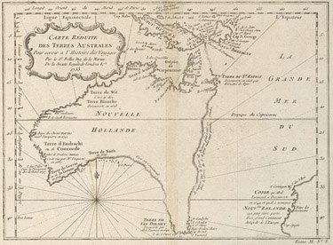
This is a black-and-white map of Australia (labelled 'NOUVELLE HOLLANDE' or New Holland) and some surrounding areas, by Jacques Nicolas Bellin (1703-72), a French cartographer. The map shows the northern and western coastlines of New Holland (Australia), as well as the only partially charted eastern and southern coastlines. Part of the coastlines of New Guinea and New Zealand are also shown. The map was published in Paris in 1753 by Chez Didot and measures 19.0 cm x 25.6 cm.
Educational value
- This asset is an example of the work of Jacques Nicolas Bellin, a well-known French hydrographer and chief cartographer of the French Navy - Bellin, a member of the Royal Society of London and the Académie de Marine, produced several important maps of Canada and North America as well as working on this map of Australia, which shows the western and northern coastlines in fine detail; what was known of the eastern and southern coastlines has also been drawn, although with significantly less detail.
- It shows what was known of the coast of 'TERRE DE VAN DIEMEN' in 1753, which on this map is shown as being joined to the mainland - Van Diemen's Land, now called Tasmania, was believed to be part of the mainland until Matthew Flinders (1774-1814) circumnavigated the island in 1798-99; Abel Tasman (1603-59) was the first European to explore this region in 1642; he named it 'Anthoni van Diemens Landt' in recognition of Anthony van Diemen, Governor-General of the Dutch East India Company (VOC, for Verenigde Oostindische Compagnie, literally 'United East Indies Company'), who encouraged exploration of Australia and surrounding regions; it was not until 1856, 103 years after this map was printed, that Van Diemen's Land was renamed Tasmania in recognition of Tasman.
- It shows detailed charting of New Holland mainly along the western and northern coastlines and part of the southern coastline - the western and northern coastlines were explored before the eastern coastline; the western half of the continent was called 'Nouvelle Hollande' or New Holland because of explorations that the VOC had been carrying out since 1606; English explorer James Cook claimed only the eastern side of the continent, in 1770.
- It demonstrates that there was still a great deal that was unknown at this time about the lands in the southern hemisphere, including 'NOUV GUINEE' (New Guinea) - the first published map of New Guinea dates from 1600 and although the first European contact with the island, possibly by either Portuguese or Spanish sailors, took place in 1526-27, by the mid-18th century only the northern and western coasts had been mapped with any degree of accuracy; in this map much of the southern and eastern coasts of Australia and of eastern New Guinea is uncharted.
- It shows part of the western coastline of New Zealand - Abel Tasman was the first European to discover New Zealand, in 1642, when he sailed along the west coast of both South and North Islands; early maps show that Tasman named this land 'Staten Landt', mistakenly believing it to be off the coast of Chile; this was changed to 'Nova Zeelandia' by the Dutch in about 1643 and subsequent maps use this name; the map shown here records the French spelling of the name.
- It is an example of 18th-century cartography - cartography is the science of making maps and globes; the earliest known map dates from the 7th century BCE, but the latitudinal and longitudinal grid, a familiar feature of modern maps, was developed only in the 2nd century CE, by Claudius Ptolemy, a Greco-Egyptian astronomer, mathematician and geographer; this was an important development, making it easier to chart the position of landmasses.