Description
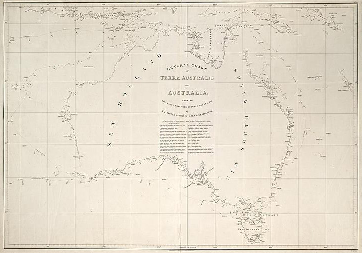
This is a highly significant black-and-white map of Australia depicting areas explored by Matthew Flinders between 1798 and 1803. The map is entitled 'GENERAL CHART OF TERRA AUSTRALIS OR AUSTRALIA'. The different ships and routes that Flinders took while charting the coastline of the continent are included, as well as details of dates, meteorological information and navigational information, although most of this information is not visible on the reproduction. The map, measuring 63.1 cm x 91.7 cm, was first published in London in 1814 as part of Matthew Flinders's book 'A voyage to Terra Australis'.
Educational value
- The title of the map includes what was probably the first use of the word 'Australia' in a published work to describe the actual continent rather than a wider unknown area of the South Pacific region. The name 'Australia' had first been used by Alexander Dalrymple in 1771 to describe the South Pacific and was later used by George Shaw and Sir James Smith, in 1793, when they wrote a botanic history of 'Australia, Australasia or New Holland'. It was Matthew Flinders, however, who promoted the official use of the name, first in private communication with his brother in 1804 and later that year in a chart 'of Australia' that he sent to Sir Joseph Banks. That chart forms the basis of this revised version, published in 1814.
- Flinders used both 'Terra Australis' and 'Australia' on his chart because British authorities preferred the name 'Australis', the Latin word for 'southern', which came from the term 'Terra Australis Incognita' (unknown southern land). It was not until this map was published in Flinders's 1814 book that the name 'Australia' became well known by the public. Three years later the New South Wales Governor, Lachlan Macquarie, proposed that the name be formally adopted, although it would take another seven years before the British Admiralty officially agreed to the name in 1824.
- The map records numerous explorations made between the years 1798 and 1803 by Flinders aboard the Norfolk, the Cumberland and the Investigator. After his role circumnavigating Van Diemen's Land (Tasmania) in 1798, Flinders was given command of HMS Investigator in 1801, this command leading to one of his most significant voyages, as he was able to sail along the western and southern coastlines, as well as to rechart the eastern coast previously explored by James Cook. As a result of his voyages, Flinders proved that New Holland and NSW were part of the same landmass, and effectively outlined the shape of the whole continent.
- Flinders charted areas along the coast of modern-day South Australia, including Spencer Gulf and the northern coast of Kangaroo Island. It was near here that he encountered the French explorer Nicolas Baudin in Le Géographe, Baudin having been sent to map the southern coast by the French Government. This meeting, at a place Flinders later called Encounter Bay, was peaceful despite both Flinders and Baudin believing that Britain and France were at war.
- The map shows complete details of Bass Strait, which separates Van Diemen's Land, now called Tasmania, from the mainland. Until Flinders circumnavigated the island in 1798 on board the sloop Norfolk, Van Diemen's Land was believed to be part of the mainland. This discovery was important as it meant that the journey between Sydney and India could be shortened by a week.
- The placenames on the map, most not visible in the reproduction, are those in use in the region in 1814 and while many placenames are familiar today, including Timor, Java and the Gulf of Carpentaria, this is not the case for all the placenames, Port Jackson being used instead of Sydney for example.
- The name 'New Holland' continued to be used on many early maps, particularly for the western part of the continent. This map reveals that Flinders differentiated New Holland from NSW along longitude 135 degrees east. It was not until about 1820 that the name 'New Holland' was dropped from regular use.
- The map is taken from Flinders's book 'A voyage to Terra Australis', published in London in 1814. The main reason for the long delay between the voyages of exploration and publication of the resulting maps and book was that while returning home to England in 1803 Flinders was captured as a spy by the French governor of Mauritius, General Decaen, and imprisoned on the island. He was not released until 1810. Upon his release, Flinders worked on this book for four years despite ill health. He died the day after the book was published, on 19 July 1814.
- Flinders provided detailed nautical information on the map, adding details on the movements of his ship as well as the wind direction, depth of ocean, currents and shoals that he encountered on his voyages. He also included placenames and dates, showing details of the route and direction that he took in exploring the coastline. This type of detail is often missing in other commercially produced maps and indicates Flinders's intention to preserve information for later navigators and his commitment to the scientific exploration of Australia.